BATHYMETRY / WATER INTELLIGENCE

BATHYMETRY / WATER INTELLIGENCE

BATHYMETRY / WATER INTELLIGENCE

Depth intelligence for
working waterways.

Depth intelligence for
working waterways.

Depth intelligence for
working waterways.

Blue Streak Geospatial uses vessel-based sonar to document underwater conditions for marinas, channels, dredging projects, and coastal monitoring. Turn soundings into depth models and spatial data tied to an agreed reference datum.

Blue Streak Geospatial uses vessel-based sonar to document underwater conditions for marinas, channels, dredging projects, and coastal monitoring. Turn soundings into depth models and spatial data tied to an agreed reference datum.

Blue Streak Geospatial uses vessel-based sonar to document underwater conditions for marinas, channels, dredging projects, and coastal monitoring. Turn soundings into depth models and spatial data tied to an agreed reference datum.

Explore the depth model

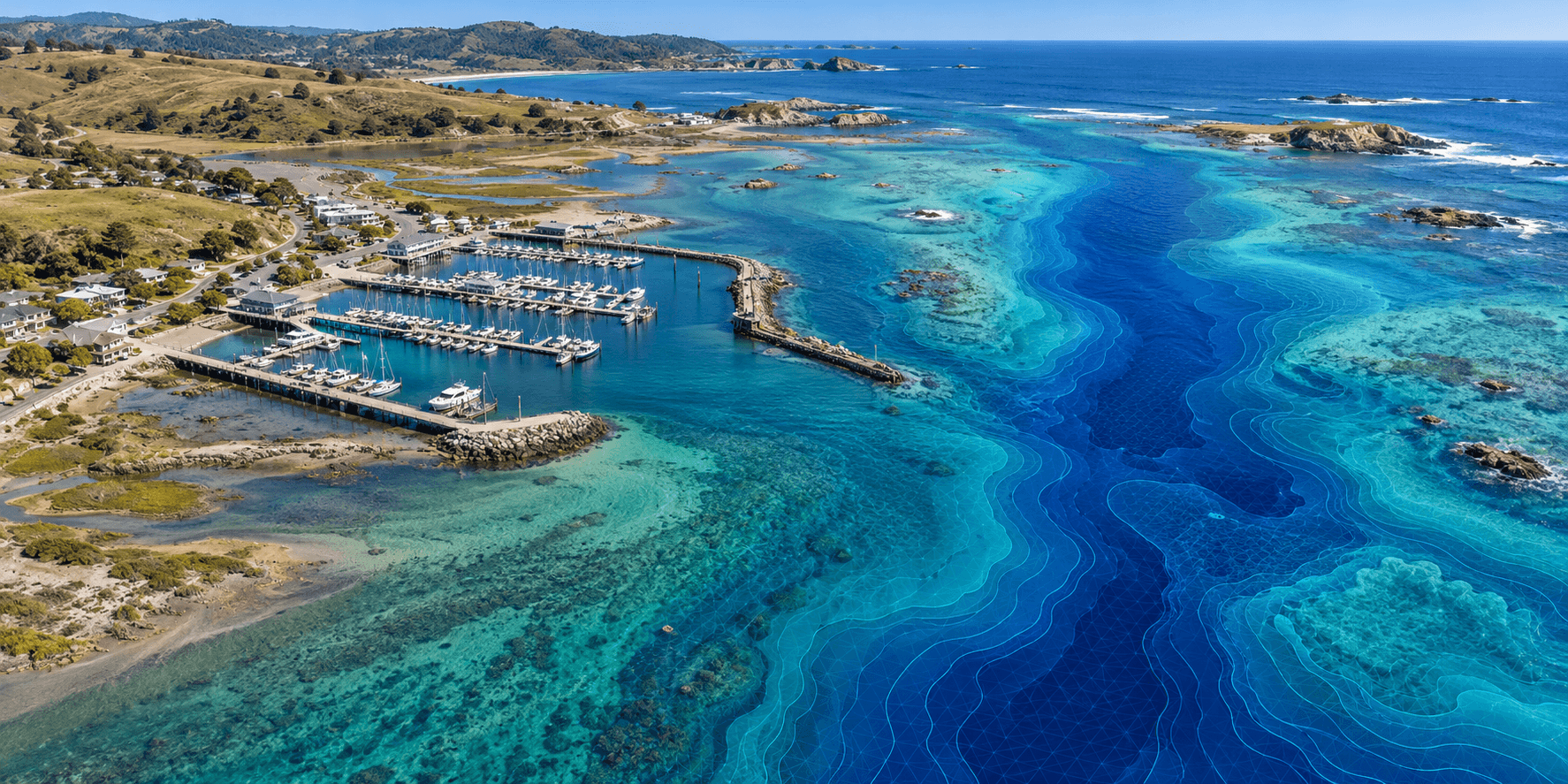
Realistic illustrative aerial view of a coastal marina, clear turquoise water, and bathymetric seafloor contours
BATHYMETRY / COASTAL INTELLIGENCESONAR / DEPTH PROFILE
REVEAL THE DEPTHDepth data.
Operational context.
Depth models · Channel conditions
01 / DATA OUTPUTDepth model

Depths tied to a vertical reference.

02 / DATA OUTPUTSeafloor contours

Channel geometry and shallow areas.

ILLUSTRATIVE SCENES / SIMULATED SCANS
01 / DATA OUTPUTDepth model

Depths tied to a vertical reference.

02 / DATA OUTPUTSeafloor contours

Channel geometry and shallow areas.

Aerial intelligence. Precision data for land and water.

BATHYMETRY

BATHYMETRY

FROM SOUNDINGS TO SURFACE

FROM SOUNDINGS TO SURFACE

FROM SOUNDINGS TO SURFACE

Inspect the depths behind the decision.

Inspect the depths behind the decision.

Inspect the depths behind the decision.

Explore how sonar measurements become a bathymetric surface. This interactive example shows simulated depth gradients, contours, and individual soundings. Actual project data is collected and processed to the agreed coverage, reference system, and deliverables.

Explore how sonar measurements become a bathymetric surface. This interactive example shows simulated depth gradients, contours, and individual soundings. Actual project data is collected and processed to the agreed coverage, reference system, and deliverables.

Explore how sonar measurements become a bathymetric surface. This interactive example shows simulated depth gradients, contours, and individual soundings. Actual project data is collected and processed to the agreed coverage, reference system, and deliverables.

WHERE DEPTH DATA MATTERS

WHERE DEPTH DATA MATTERS

WHERE DEPTH DATA MATTERS

Document conditions. Plan the work.

Document conditions. Plan the work.

Document conditions. Plan the work.

Marinas & vessel access

Marinas & vessel access

Marinas & vessel access

Document basin, berth, and approach depths to identify shallow constraints. Give marina teams a current depth record for larger-vessel access planning, maintenance priorities, and operational risk reviews.

Document basin, berth, and approach depths to identify shallow constraints. Give marina teams a current depth record for larger-vessel access planning, maintenance priorities, and operational risk reviews.

Document basin, berth, and approach depths to identify shallow constraints. Give marina teams a current depth record for larger-vessel access planning, maintenance priorities, and operational risk reviews.

Channels & dredging

Channels & dredging

Channels & dredging

Map shoaling and channel geometry to inform marking plans and dredging assessments. Compare the mapped surface with an agreed design surface to support material estimates and project coordination.

Map shoaling and channel geometry to inform marking plans and dredging assessments. Compare the mapped surface with an agreed design surface to support material estimates and project coordination.

Map shoaling and channel geometry to inform marking plans and dredging assessments. Compare the mapped surface with an agreed design surface to support material estimates and project coordination.

Coastal monitoring

Coastal monitoring

Coastal monitoring

Establish a seabed baseline and compare repeat depth datasets to investigate sediment movement and changing underwater conditions. Where useful, combine bathymetry with separately collected shoreline or aerial data for broader coastal context.

Establish a seabed baseline and compare repeat depth datasets to investigate sediment movement and changing underwater conditions. Where useful, combine bathymetry with separately collected shoreline or aerial data for broader coastal context.

Establish a seabed baseline and compare repeat depth datasets to investigate sediment movement and changing underwater conditions. Where useful, combine bathymetry with separately collected shoreline or aerial data for broader coastal context.

FROM CAPTURE TO INTELLIGENCE

FROM CAPTURE TO INTELLIGENCE

FROM CAPTURE TO INTELLIGENCE

Explore the depth model.

Explore the depth model.

Explore the depth model.

Inspect a simulated sonar capture, from individual soundings to depth gradients and contours.

Inspect a simulated sonar capture, from individual soundings to depth gradients and contours.

Inspect a simulated sonar capture, from individual soundings to depth gradients and contours.

Bathymetry INTERACTIVE EXAMPLE
SONAR / BATHYMETRIC MODELSynthetic model · Scan paused
DEPTH BELOW SURFACE · SIMULATED
0 m7.5 m15 m
Drag · Click to inspect
LOWHIGH

Synthetic scenes and simulated measurements demonstrate potential mapping outputs. Project deliverables, reference systems, and accuracy requirements are defined for each scope.

DATA YOUR TEAM CAN USE

DATA YOUR TEAM CAN USE

DATA YOUR TEAM CAN USE

Outputs defined by your project.

Outputs defined by your project.

Outputs defined by your project.

01

01

01

Bathymetric surfaces

Bathymetric surfaces

Bathymetric surfaces

Depth or elevation models that describe the mapped bed, with coverage and reference information included for interpretation.

Depth or elevation models that describe the mapped bed, with coverage and reference information included for interpretation.

Depth or elevation models that describe the mapped bed, with coverage and reference information included for interpretation.

02

02

02

Contours & soundings

Contours & soundings

Contours & soundings

Depth contours and sounding datasets for inspecting basin geometry, channel profiles, and shallow areas at the agreed reporting scale.

Depth contours and sounding datasets for inspecting basin geometry, channel profiles, and shallow areas at the agreed reporting scale.

Depth contours and sounding datasets for inspecting basin geometry, channel profiles, and shallow areas at the agreed reporting scale.

03

03

03

Surface comparisons

Surface comparisons

Surface comparisons

Comparisons against a prior dataset or design surface, where compatible data is available, to assess change or estimate material differences.

Comparisons against a prior dataset or design surface, where compatible data is available, to assess change or estimate material differences.

Comparisons against a prior dataset or design surface, where compatible data is available, to assess change or estimate material differences.

04

04

04

Maps & spatial files

Maps & spatial files

Maps & spatial files

Map layouts and agreed GIS or CAD exports, accompanied by collection dates, coordinate references, and relevant data limitations.

Map layouts and agreed GIS or CAD exports, accompanied by collection dates, coordinate references, and relevant data limitations.

Map layouts and agreed GIS or CAD exports, accompanied by collection dates, coordinate references, and relevant data limitations.

START WITH THE REQUIREMENT

START WITH THE REQUIREMENT

START WITH THE REQUIREMENT

Define the waterway mapping scope.

Define the waterway mapping scope.

Define the waterway mapping scope.

01 /

01 /

01 /

Define the decision

Define the decision

Define the decision

Share the project boundary, intended use, vessel considerations, available records, and timeline. We establish the required coverage, reference datum, outputs, and acceptance criteria.

Share the project boundary, intended use, vessel considerations, available records, and timeline. We establish the required coverage, reference datum, outputs, and acceptance criteria.

Share the project boundary, intended use, vessel considerations, available records, and timeline. We establish the required coverage, reference datum, outputs, and acceptance criteria.

02 /

02 /

02 /

Plan & collect

Plan & collect

Plan & collect

Coordinate vessel access and operating conditions, then collect sonar observations to the agreed plan. Water levels and positioning are addressed within the collection approach.

Coordinate vessel access and operating conditions, then collect sonar observations to the agreed plan. Water levels and positioning are addressed within the collection approach.

Coordinate vessel access and operating conditions, then collect sonar observations to the agreed plan. Water levels and positioning are addressed within the collection approach.

03 /

03 /

03 /

Process & document

Process & document

Process & document

Review observations, develop the specified surfaces and maps, and document their references and limitations. Discuss findings in relation to your planning or monitoring objective.

Review observations, develop the specified surfaces and maps, and document their references and limitations. Discuss findings in relation to your planning or monitoring objective.

Review observations, develop the specified surfaces and maps, and document their references and limitations. Discuss findings in relation to your planning or monitoring objective.

BEFORE YOU COMMISSION

BEFORE YOU COMMISSION

BEFORE YOU COMMISSION

A few practical questions.

A few practical questions.

A few practical questions.

How is water depth measured?

How is water depth measured?

How is water depth measured?

This service uses vessel-mounted sonar. Aerial imagery or LiDAR can add shoreline and land context when scoped, but the depth observations described here come from sonar.

This service uses vessel-mounted sonar. Aerial imagery or LiDAR can add shoreline and land context when scoped, but the depth observations described here come from sonar.

This service uses vessel-mounted sonar. Aerial imagery or LiDAR can add shoreline and land context when scoped, but the depth observations described here come from sonar.

How should depth data inform vessel access?

How should depth data inform vessel access?

How should depth data inform vessel access?

Sonar mapping documents conditions at the time of collection. Marina teams interpret those depths alongside vessel draft, changing water levels, and operating conditions when planning access. Repeat captures can help keep that record current.

Sonar mapping documents conditions at the time of collection. Marina teams interpret those depths alongside vessel draft, changing water levels, and operating conditions when planning access. Repeat captures can help keep that record current.

Sonar mapping documents conditions at the time of collection. Marina teams interpret those depths alongside vessel draft, changing water levels, and operating conditions when planning access. Repeat captures can help keep that record current.

Can the data meet a specific project standard?

Can the data meet a specific project standard?

Can the data meet a specific project standard?

Share any engineering, dredging, or authority requirements before scoping. We review the required coverage, datum, accuracy, deliverables, and acceptance criteria with your team and confirm which requirements the proposed mapping project will address.

Share any engineering, dredging, or authority requirements before scoping. We review the required coverage, datum, accuracy, deliverables, and acceptance criteria with your team and confirm which requirements the proposed mapping project will address.

Share any engineering, dredging, or authority requirements before scoping. We review the required coverage, datum, accuracy, deliverables, and acceptance criteria with your team and confirm which requirements the proposed mapping project will address.

PUT THE WATERWAY IN SCOPE

PUT THE WATERWAY IN SCOPE

PUT THE WATERWAY IN SCOPE

What depth data does your project need?

What depth data does your project need?

What depth data does your project need?

Tell us the location, mapping area, intended use, and timing. We’ll help define a bathymetric scope around the decision ahead.

Tell us the location, mapping area, intended use, and timing. We’ll help define a bathymetric scope around the decision ahead.

Tell us the location, mapping area, intended use, and timing. We’ll help define a bathymetric scope around the decision ahead.

MORE WAYS TO UNDERSTAND YOUR SITE

MORE WAYS TO UNDERSTAND YOUR SITE

MORE WAYS TO UNDERSTAND YOUR SITE